contact
contact
ForYou Club
81 / 85 Facilities
154 / 173 Slopes
22 / 39 XC-Trails
4 °C
Webcam
Current info
Grimming-Donnersbachtal

Irdninger Moosroundtrail

Tour description

Short and flat course, which is particularly suitable for training condition and endurance - including a magnificent panoramic view.

Underground:  45% asphalt, 55% gravel

Ideal starting points and entry points:Sports facility Irdning, Trautenfels-bridge, Sallaberg-bridge

Conditional/fitness requirements:For one turn moderate stamina is enough. When adding more turns, the requirements will rise. 
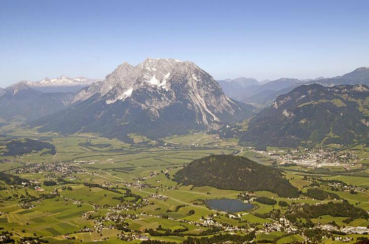
The tour

moderate
Starting and end point Sports facility Irdning
Tour characteristics
Fitness (3/6)
Information
Distance: 6.26 km
Duration: 55 min
Ascent: 31 m
Descent: 31 m
highest point: 670 m
Best season
Jan
Feb
Mar
Apr
May
Jun
Jul
Aug
Sep
Oct
Nov
Dec

Map, elevation profile & further information

Trail number: 15
  • From Schladming/Salzburg on the B320 to Pürgg-Trautenfels.
  • From Bad Aussee/Bad Ischl via the B145 to Pürgg-Trautenfels.
  • FromTrautenfels towards Irdning, past the Putterersee to Aigen.
  • From Liezen/Graz on the B320 to Wörschach, past the barracks with the airfield to Aigen.
Sports facility Irdning
With the train to ,,Stainach-Irdning'' or ,,Liezen'' and than with the bus 940/941 to the busstop ,,Irdning Abzweigung Donnersbach''.

All informations under:

www.oebb.at

www.verbundlinie.at

  • Plan your trail in advanceInform yourself about the course of the trail and its demands
  • Pay attention to weather forecasts and weather changes
  • Let others know where you are going
  • Adapt your equipment to the weather and the trail
  • Be aware of livestock when crossing pasture
  • Trail running shoes - no asphalt running shoes
  • Running backpack or vest depending on the length of the tour hydration bladder or softflasks
  • thin windbreaker
  • first aid kit, including emergency blanket
  • cell phone
  • energy bar
  • money
  • change of shirt
  • Headband
  • Sunglasses
If one turn is too short for you, you can extend the track along the track as you like. For advanced runners, we recommend the extension round the Kulm (Kulmrunde).  Tourism information: www.schladming-dachstein.at

Tourism blog: www.derbergdastal.at

www.schladming-dachstein.at/de/Sommer/Wandern-und-Bergsport/Laufen-und-Trailrunning

Tourist Office Schladming-Dachstein

Ramsauerstrasse 756

8970 Schladming

T: +43 3687 23310

info@schladming-dachstein.at

Garbage on meadows and paths can not smell mountain and valley. Please take it with you. Agriculture and forestry are important partners for Berg und Tal. They allow you to walk and drive on many of their paths. Be aware that only good cooperation will guarantee your recreational enjoyment in the future.

  •  Trailrunning map Schladming-Dachstein: available free of charge at all info locations

Wheather predicition

today
23.02.2026
Mountain 3 °C
Valley 11 °C
Snow
Mountain
9 cm
Valley
0 cm
Wind speed
Nordwest
15 km / h
Precipitation
Probability
90 %
Amount
15.2 l/m²
Sun
Sun hours
1.3 h
Sunrise
06:55 o clock
Sunset
17:39 o clock

Mostly cloudy with a chance of light snowfall around noon, then the clouds will break up.

tomorrow
24.02.2026
Mountain 0 °C
Valley 9 °C
Snow
Mountain
9 cm
Valley
0 cm
Wind speed
Nordwest
15 km / h
Precipitation
Probability
90 %
Amount
11.7 l/m²
Sun
Sun hours
0 h
Sunrise
06:54 o clock
Sunset
17:41 o clock

Constant snowfall through the day. Slow-down towards evening.

day after tomorrow
25.02.2026
Mountain 6 °C
Valley 13 °C
Snow
Mountain
0 cm
Valley
0 cm
Wind speed
Nordwest
5 km / h
Precipitation
Probability
0 %
Amount
0 l/m²
Sun
Sun hours
9.8 h
Sunrise
06:52 o clock
Sunset
17:43 o clock

Early morning clouds will clear soon. The rest of the day will be dry and bright with plenty of sunshine.

Tours nearby